
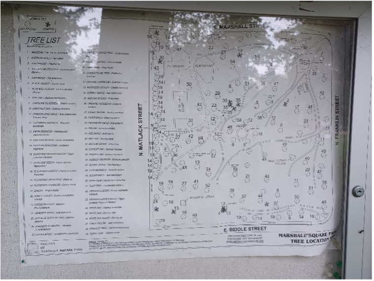
Tree Location Map
In 2012, a TREE LOCATION MAP was developed which includes a Full Park view Sheet, four pages of numbered tree park-quadrant Maps, and a Tree Inventory List. Jeffrey C. Beitel Architecture donated the services to produce the final TREE LOCATION MAP, including a poster-sized version for the Park’s bulletin board.
We hope you print out—or view on your tablet—the TREE LOCATION MAP and walk through Marshall Square Park to familiarize yourself with the many wonderful trees we are fortunate to have in West Chester’s original park, established in 1848!
Fast forward to 2023, and we are in the process of updating this map for the several trees that have fallen or been removed, and the many trees that have been added, including a dozen new, native trees planted this year. STAY TUNED!
Tree Identification and Labeling
Marshall Square Park’s Trees—have you ever wondered what their names are?
In 2012, the Friends of Marshall Square Park (FMSP), with funding from the Humphry Marshall Foundation, completed a long-term project conceived years ago and identified as a priority project.
Because of the Park’s early origins as an arboretum, FMSP wanted to give the public information on the important, original trees still standing. Few of us would know them—much less their names—without help. Fortunately, D.L. Howell & Associates, Inc., very generously donated their professional services to produce an accurate Existing Conditions Survey of Marshall Square Park.
Although a long-term priority, the project languished behind other, critically needed improvements until FMSP member Oliver Snow expressed interest in helping identify our trees. A committee, chaired by Founding Member and Past President Anne Walters, researched recommended materials for the labels and proper installation with help from Longwood Gardens and the Morris and Jenkins Arboretums. Steven Wright, a Hamilton Fellow at Jenkins, assisted in identifying obscure tree varieties. Anne coördinated with the sign maker to develop quality aluminum labels to mark each tree with its common and Latin names.
After more than a year of preparation and work, Anne ordered the labels; on February 21, 2012, they were installed using a system of stainless steel screws and springs that allow the trees to grow and expand unharmed.

In 2022, the Humphry Marshall Foundation again offered funding for us to update the tree labels, with larger, easier to read ones which Roger Lacy, FMSP Board member, procured, and mounted. As this year of 2022 was a celebration of Marshall’s 300th birthyear, these new labels were made for those large trees (over 18” diameter) which were of genus and species identified in Humphry Marshall’s historic native tree compendium published in 1785 – “Arbustrum Americanum: The American Grove”. In this historic publication, Marshall provided the first publication of native American trees and shrubs, several species of which are present in Marshall Square Park.
And in 2023, Roger identified and mounted additional tree labels for other large trees in the park which were not identified in Marshall’s publication.
We are very proud to have completed these projects that make Marshall Square Park both an historic and horticultural interest destination. Plus now, the names and origins of our historic trees are no longer a mystery!
What our Marshall Square Park Trees Do for Us:
Have you ever thought about what our trees do all day, every day?
An email volley called What’s happening to the trees? circulated because of the removal of many mature trees during High Street’s sidewalk renovation and drew in local experts.
Besides the beauty and shade that trees provide, a tree with a 24-inch caliper will typically store more than 100 pounds of carbon, because trees are largely composed of carbon.
To achieve this caliper, the tree has to remove more than 367 pounds of CO2 (a global warming pollutant) from the air. The bigger the tree, the more carbon it stores, and the more CO2 it removes from the air.
As long as a tree is healthy and not extremely old, it keeps taking out more carbon each year. Planting a new, young tree in place of a mature tree cannot mitigate the lost benefit; it takes about sixteen (16) young trees to make up for the loss of one mature tree.
So, now you know what our MSP trees are doing all day, every day, and their names, too!